The weekend storm will be remembered for decades, and there were few other occasions in which the weather caused so much havoc around the islands.
Weather Facebook page “It-temp madwarna” gave a lengthy explanation of the phenomenon, along with photos taken by satellite between midnight and 4am on Sunday.
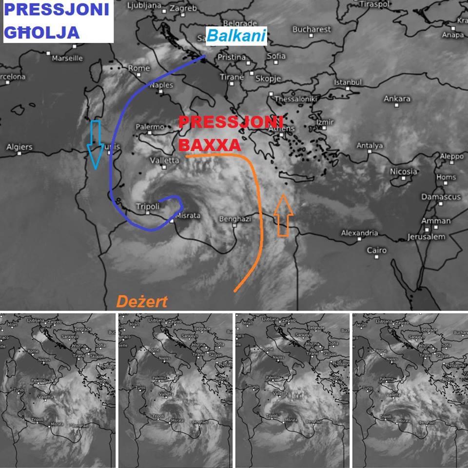
1. It all started when a front of air which was colder than normal accompanied with strong winds (blue arrow) from the Balkans came over the Mediterranean. When this cold air arrived over Makta, temperatures as low as 2 degrees were registered in Dingli and some parts of the south of Malta were hit by a hailstorm. The 2 degree temperature was just higher than the record low of 1.4 degrees ever registered. The wind chill made its effect even harsher, and the temperature was felt at minus six degrees. On Saturday, the highest temperature registered was 16 degrees, meaning that there was a huge drop in temperature in a few hours.
2. While the cold front continued its way towards Tunisia and Libya, warmer and more humid currents from the Sahara Desert, the Ionian Sea and the Gulf of Sirte interacted with this cold front (orange arrow).
3. At this point, what happened was what American meteorologists describe as bombogenesis, which is a rapid intensification of a depressive system. The atmospheric pressure came down from 1025mBar to 999mBar in less than 24 hours. This is a very rare phenomenon in the Mediterranean and normally occurs in the Pacific or Atlantic Oceans where atmospheric pressure and temperature experience a rapid change.
4. The sea was seen to be at a lower level than normal. The wind was absent (the calm before the storm) and fish that normally lives 100-300 metres below the surface ended up much closer. This took place because the centre of the low pressure area started to pull up air to strengthen itself and turn into a cyclone.
5. In such a cyclone, which goes anti-clockwise, the northeastern flank is normally the most intensive. When the centre of the cyclone was closest to the Maltese islands, positioned in the southeast, the wind reached Force 10 and later Force 11 for about four hours, hitting mostly the northeastern (grigal) side of the islands. The strongest gust measured in Valletta was 133 km, a record for the Maltese Islands.
6. Band of rain were also experienced, including lightning and thunder, in various parts of Malta, particularly the south and much less in Gozo. The amount of rain measured was between 10mm in Gharb and 93mm in Siggiewi.
7. The waves reached a height of more than 10 metres, and the waves reached above the bastions in Valletta and caused havoc in areas such as St Julian’s, Sliema and St Paul’s Bay, on the north eastern coast.
8. The temperature of the sea was 15 degrees at the time of the cyclone, and cannot be therefore classified as medigan, as this normally occurs in warmer seas and has a more symmetrical form and warm core.