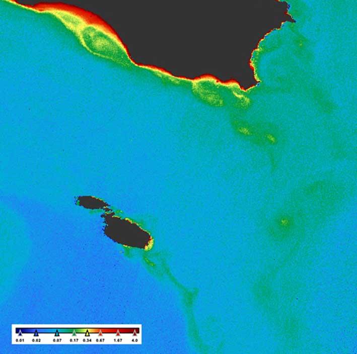
Remotely sensed satellite data are increasingly becoming an essential resource in applications to improve the quality of life and safety of citizens, for risk assessment, environmental monitoring, surveillance, scientific discovery, as well as economic exploitation. WaterColours is a project that exploits the use of satellite imagery for the estimation of water quality parameters in the Malta Channel (the stretch of sea that divides our archipelago from Sicily) with a focus on the area around the Maltese Islands. The primary aim is to generate (or paint), high resolution (with a very fine brush), maps that show the environmental condition of the water (as different colours) in this marine domain.
The first phase of the project that is nearing completion, focused on the calculation of the occurrence and periodicity for surface Chlorophyll-a (Chl-a) concentrations and Total Suspended Matter (TSM). Apart from identifying the general trends of these parameters, the results will provide important indication of eutrophication as well as suspended sediment loading or depletion areas. This was possible through the processing of 10 years of data captured between 2002 and 2012 by the MEdium Resolution Imaging Spectrometer (MERIS) sensor, on-board the polar-orbiting Envisat-1 research satellite by the European Space Agency (ESA). The merging of the long time-series allowed the generation of high-quality climatologies that show how Chl-a and TSM vary on a daily, weekly and monthly basis without the limitations observed in the raw data caused mainly due to atmospheric phenomena.
The second phase of the project will focus on the operational computation of satellite data products at an unprecedented quality and resolution. This will be carried out by using the data from the SENTINEL 3A and 3B satellites which were launched in February 2016 and April 2018 respectively. Although these datasets are being used extensively for the Europeans waters for estimating Chlorophyll-a and TSM from the viewpoint of coastal management and research purposes, our main aim is to significantly improve the quality of the outputs and make them more suited to the Water Framework Directive (WFD) as well as the Marine Strategy Framework Directive (MSFD). The products will be calibrated and validated using field measurements that will be obtained from dedicated field surveys to be carried out in the coming months around Malta, Pozzallo and Lampedusa. For this activity, the team from the Physical Oceanography Research Group of the University of Malta will be working with experts from the Institute of Marine Sciences within the Italian National Research Council (CNR-ISMAR) to collect and analyse the measurements.
Subsequently, all the data generated in this project will be uploaded to an online portal that will render the near real-time publishing and visualisation of the targeted products thereby enabling scientists and other stakeholders such as fishermen and local environmental agencies to make informed decisions regarding the utilization and management of the marine resources. The user interface will be powered with Artificial Intelligence to enable the continuous monitoring and detection of the changes in water quality parameters. This is essential also from the perspective of identifying and monitoring isolated events of increased Suspended sediments triggered by heavy rainfall or development activities, as well sudden appearances of algal blooms in the Maltese waters.
WaterColours is a project approved for funding by the Malta Council for Science & Technology, for and on behalf of the Foundation for Science and Technology, through the Space Research Fund. The project is coordinated by Dr Adam Gauci and Prof. Aldo Drago with the support of Dr Ankita Misra from the Physical Oceanography Research Group within the Department of Geosciences of the University of Malta. The main aim of this initiative is to ensure capacity building, to increase the use of satellite datasets for the monitoring and management of the marine and coastal environment around our island, as well as to highlight our stronger presence in the European space sector.
More information on the project can be obtained from https://watercolours.capemalta.net