Malta's electoral map is set to change, as Parliament will soon debate Electoral Commission proposals for some district lines to be re-drawn in view of population changes in the last half decade.
It's a topic which has attracted some debate: on the one hand, the Labour Party is backing a proposal which will see fewer voters shifted around but more localities split up, and on the other hand, the Nationalist Party is backing a proposal which will see the electoral map radically redrawn so almost no localities are split up.
The Malta Independent on Sunday delves into what may happen - looking at why the districts need to change in the first place, who is proposing what, and what the impact and issues may be.
Why do the districts need to be changed?
The review of the boundaries of Malta's electoral districts is a process governed by the Constitution.
Article 61 states that the district boundaries have to be reviewed by the Electoral Commission "at intervals of not less than two nor more than five years", after which review the boundaries may be altered if it is deemed necessary to do so.
Districts are adjusted to ensure that the voting population size in each of them remains relatively equal, and changes to boundaries must take things like geographical vicinity - ergo, not having two localities at either end of the island in the same district - and difference in density of population.
The system that the Constitution outlines stipulates that no district can be more than 5% bigger or smaller than the average district population of the electorate.
The only exception is Malta's 13th district, which is the island of Gozo. The Constitution stipulates that Gozo cannot be divided between two or more districts, even if its population is significantly lower or higher to that of all of the other districts.
This was a provision introduced when it was realised that Gozo's population was set to increase beyond the 5% allowable threshold. This meant that Ghajnsielem was initially hived off into the 12th district on the main land in 2005, but ultimately the powers that be amended the Constitution to establish the proviso that preserved Gozo as a single district in time for the 2008 general election.
The last time electoral districts were adjusted was in February 2021 when around 2,500 voters - 1,320 from Żebbuġ and 1,219 from Naxxar - were shifted to different electoral districts to make up for the 7th and 12th districts exceeding the 5% threshold.
What does the math say this time?
Just over four years have now passed, and with two years to go before the next general election is scheduled, a new review of the electoral districts is on the cards.
The latest electoral register, published in October 2024, indicates that Malta has 355,409 voters - a figure which is practically identical to the 355,075 voters that were registered for the 2022 general elections.
31,608 of those on the latest electoral register reside in Gozo, meaning that they are all on the 13th district. The remaining 323,801 votes are split between the remaining 12 districts on the mainland - translating to an average of 26,983 voters per district.
The 5% threshold is therefore worked out to be of 1,349 voters - which means that an electoral district can have a maximum voting population of 28,332 people and a minimum voting population of 25,634 people.
A district-by-district analysis of the current electoral register shows the need for immediate changes to three districts: the voting population of the 1st district registers at 7.58% below the district average, while the 12th district registers at an identical 7.58% above the district average. The 7th district meanwhile registers at 5.46% above the district average, meaning that it too - albeit marginally - is above the threshold.
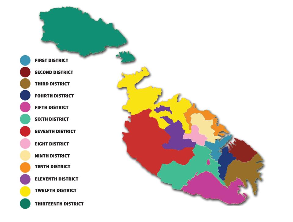
The 1st district is currently made up of Valletta, Floriana, Hamrun, Marsa, Pieta and Santa Venera. It used to be based largely around Valletta, but population decline in and around the capital has meant that the district over the years has had to be widened to include more localities.
The 12th district meanwhile is currently made up of St Paul's Bay - now Malta's most populous locality, Mellieha, and part of Naxxar, while the 7th district is made up of Rabat, Mtarfa, Mgarr, Dingli, and part of Zebbug.
Other districts all fall within the plus or minus 5% threshold - the 9th district is on the more marginal side (4.49% below the average) as is the 3rd district (4.27% above the average).
Who is proposing what?
There are two proposals on the table: the majority report, which is prepared by the Electoral Commission members from the government, and the minority report, which is prepared by the Electoral Commission members from the Opposition.
The majority report outlines a total of 10 changes to the electoral districts which will affect a total of around 21,000 voters.
The most significant changes come to the 8th district. This is currently made up of Birkirkara, Balzan, Iklin and Lija, but the proposed changes would see 4,177 voters in Birkirkara - which includes all 1,113 residents of Fleur-de-Lys - transferred to the 1st district.
Strangely however, at the same time, the locality of Pieta will be transferred to the 9th district, while the population shortfall from taking part of Birkirkara out of the 8th district will be made up by adding 6,051 voters from Naxxar instead.
The remaining 4,931 voters in Naxxar will be in the 10th district. Naxxar used to be split between the 10th - where there was Baħar iċ-Ċagħaq - and the 12th electoral districts. It's the second time in a row that the electoral boundaries for Naxxar will have been adjusted.
The locality of Marsascala will also be split: 730 voters from the L-Għolja taż-Żonqor area will be shifted to the 2nd district, which is based around the Three Cities and Zabbar.
Meanwhile, previous locality switches will now be reversed: all of Zebbug will be in the 7th district having previously been split between the 6th and 7th, and all of Luqa will now be in the 6th district, with the area of Hal-Farrug having previously been in the 5th.
Burmarrad will also move to the 12th district with the rest of St Paul's Bay and so will the locality of Mgarr, meaning that the 11th district is made up of solely Attard and Mosta.
The minority report meanwhile is altogether more radical. It envisions changes which will affect some 186,000 voters - over half the electorate - and would essentially redraw the electoral map.
No mainland district would be spared of any changes: the 1st district would see Marsa replaced with Msida; the 2nd district will still be based around the Three Cities but would then have Zejtun and all of Fgura rather than Zabbar, Kalkara, Xghajra, and just part of Fgura.
The three localities moved out of the 2nd district would be shifted to the 3rd district, joining Marsascala. Ghaxaq and Marsaxlokk, meanwhile, would move from the 3rd to the 5th district instead.
The 4th would expand to include Luqa and Marsa instead of part of Fgura, while Qrendi, Kirkop and Mqabba would all move to the 6th district which would only retain Zebbug and Siggiewi from its original localities.
The 7th district would change completely: it currently includes Mtarfa, Dingli, Mgarr, Rabat, and part of Zebbug - but under the minority report it would include Qormi, Mdina, Attard and Balzan instead.
The 8th district would be made up of Birkirkara and San Gwann, while the 9th district would incorporate Mosta, Iklin, Lija, Gharghur and Madliena. Currently it is made up of Gharghur, Msida, San Gwann, Swieqi and Ta' Xbiex.
The 10th district would remain based around Sliema, St Julian's and Gzira but would have Pembroke and part of Naxxar removed from its borders and replaced by Swieqi and Ta' Xbiex.
The 11th district would also completely change. It is currently made up of Mdina, Attard, Mosta and Burmarrad, but under the minority report it would be made up of Naxxar, Pembroke and St Paul's Bay instead.
The 12th district would remain based around Mellieha - but while in the current electoral borders the district is drawn to the north east, in this proposal it would be drawn to the north west and include the localities of Mgarr, Dingli, Rabat and Mtarfa.
In both proposals, the 13th district would remain untouched, as per the Constitution.
What is the reasoning behind each proposal?
There are two distinct patterns of reasoning seemingly governing this report.
The authors of the majority report seem to favour changing things for fewer voters - even if it means having to split some localities.
This isn't anything new: there has been at least one locality which is split across two districts in every election since 1976. Even the minority report includes one locality split between two districts - Swieqi is proposed for the 10th district, while Madliena (which falls under Swieqi's umbrella) would be in the 9th district.
Birkirkara, for example, was split between the 8th and 12th districts in 1976, and in the same year Lija was split between the 1st and 12th districts as well - which meant that part of Lija was in the same district as Valletta, Paola and Marsa while the other part of the locality was joined with St Paul's Bay, Gharghur and part of Birkirkara.
Other localities have a history of being split and shifted around: Zabbar, for instance, was split between the 2nd and 3rd districts between 1981 and 1998 before it was united in the 3rd district in 2003 only to then be moved back to the 2nd district in 2005 where it remains today.
Fgura is another such case: first split between the 2nd and 4th district in 1981, it was united again in the 2nd district in 1987 - where it stayed until it was moved to the 3rd district in 2005. In 2011 it was then split again, this time between the 3rd and 4th district, and in 2016 it was split between the 2nd and 4th district.
The authors of the minority report meanwhile have favoured an electoral map where localities are - if possible - not split up, even if it means that whole districts need to be redrawn.
It's not the first time the PN has made such a proposal: when the electoral districts last came up for discussion back in 2021, the PN's appointed Electoral Commission members drew up a similarly radical proposal on the basis that it would minimise any post-election adjustments through proportionality mechanisms and the like.
But, oddly, when the topic came up for discussion in Parliament, PN MPs chose to disregard the proposal written by their party's own nominees and back the majority report instead.
Will it make much of a difference in the next election?
In terms of the final result of the election - the district borders won't make much of a difference at all.
The reason for this is because, ever since 1987, as long as there are two parties elected into Parliament it's the one with the most votes which will win the election - irrespective of whether they've won more seats than the other party or not.
This Constitutional provision was introduced specifically to avoid gerrymandering of the electoral districts after Dom Mintoff's Labour Party was elected to power in 1981 despite the Nationalist Party actually winning more votes.
So effectively today, parties can re-draw the districts how they like - at the end of the day if Parliament will remain a bi-party one, then it's the party with the most votes which will win.
So, why the fuss?
While there won't be an impact on the final result of the elections, there are some arguments to be made on this whole process.
The main one is that any changes to electoral districts can make the lives of individual candidates a little more difficult.
Picture it: a politician has been working a particular locality for several years, only for it to be moved to a district that he or she does not contest on - meaning that they've got to rethink their canvassing plans.
So if you're in an electoral candidate's shoes - it's probably the case that the fewer changes there are, the better, and it's also probably why the minority report would be quite a headache for them to adapt to since over half the electorate would be switching districts.
There is also the argument of keeping localities intact. The PN particularly has argued that keeping localities intact would strengthen residents' voices when it comes to sharing their concerns.
One can also argue that splitting a locality would leave it in a bit of a No Man's Land: for example, the realities faced by those in places such as Valletta and Floriana are vastly different to those faced by residents in Fleur de Lys and Birkirkara, yet under the majority report those areas fall under the same electoral district.
Finally, one can maybe spare a thought for the voters affected. Under Malta's electoral system, voters vote for specific candidates - it means that tens of thousands of voters have (for better or for worse, some might argue) a relationship with politicians.
The sun may now rise, and those voters are no longer represented on a district basis by that politician - and they can't vote for them to do so - because they've been shifted to another electoral division.
Could it reduce voter participation, because some voters may not feel as comfortable voting for candidates they are less familiar with?
Irrespective of all of this however, one way or the other, the two major parties have their hands tied by the country's demographic trends and, in turn, by the mathematical formula which maps them out.
So whether there is an impact or not, some districts simply will, indeed, have to change.